PHOTOGRAPH OF THE WEEK - 5 October 2006
Wynston Cooper, ARPS

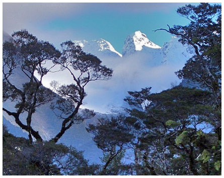
''Hollyford View' was taken along the Hollyford Track in Fiordland National Park on Sunday 4 June 2006. The weather we experienced there over Queen's Birthday was the reverse of what we expected (i.e. we had steady rain on Saturday, clearing on Sunday whereas the forecast was for fine on Saturday and becoming cloudy with the potential for some rain later on the Sunday). It was taken on a Casio EX-Z57 'point and shoot' digital camera.
As an ornithologist and keen photographer I regularly use your site, having found it the most accurate indicator of long-range weather available.
Keep up the good work' wrote Wynston.
Alan Thomas, NIWA

Alan Thomas, NIWA

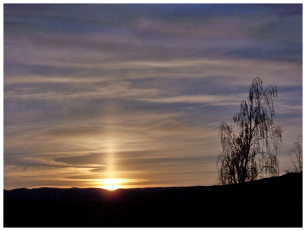
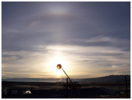
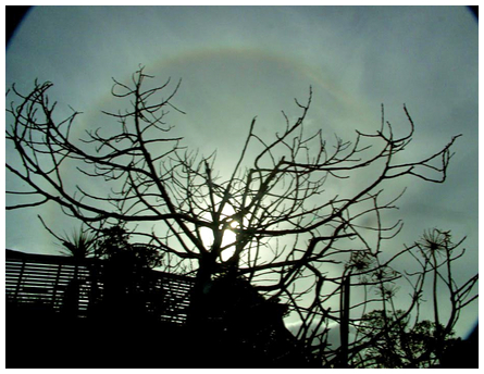
'We had an interesting sun pillar this morning (8 June 2006). This was
clearly visible as we drove out to Lauder and I took a picture when
we arrived. The sun pillar is still clearly visible, 0930, and
extends both above and below the Sun. For a brief time a halo was
visible with three false suns' wrote Alan.
'I understand that the pillars are caused by grazing reflections from
the lower horizontal faces of (ice) plates from 'Color and Nature of
Light' by David K. Lynch and William Livingston.'
Alex Parnham

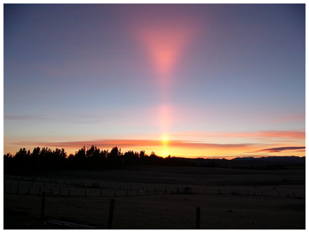
'This is an awesome sunrise in Teanau in March 2006' wrote Alex.
Since publishing Alex's superb photograph we have received the following commentary from Ian Cooper. 'Alex Parnham's shot is not only a fine sun pillar but the pillar is capped with the rare upper tangent arc which appears as a steep V-shape at sunrise. The upper tangent arc flattens out to an arc capping a normal 22° halo when the sun reaches 30° in altitude' wrote Ian
Paul Moss

'We had quite a lot of skyborne ice crystals last weekend in Wellington, (9/10 September 2006) resulting in beautiful night and day skies. The numerous cloud layers were distinctly separate from each other, and in very delicate light greys. I took the city skyline at full moon drumming near civic square. I imaged moon halos late on Friday night and early on Sunday morning (02:00). I watched sun halos on Saturday and Sunday afternoon from the top of Melrose, a fantastic place to see Raukawa (Cook Strait). We saw myriads of life-like forms in the cumulous profiles. Please enjoy and feel free to post on your site' wrote Paul.
Paul Moss

Paul Moss

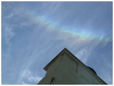
Paul wrote 'I have had a rare experience in Auckland today (11 July 2006), and attached the pics for you, use if you wish.
....just after I said I had never seen a clear sun dog, I get one that is un-believably bright!!. If I hadn't seen it I would doubt that any ray could be that bright. We had a halos fading up and down all afternoon, although never much more than a very subtle brightening and slight colour, but at 15:06 a sun dog appeared at the southern most edge of the halo, and was there for 4 minutes. When it began the left-hand side (southern) extended out with very bright white light, the colours being on the right-hand side, in line with the faint halo. After it faded another ray appeared almost overhead, a CZA (circumzenithal arc) (shown in the photograph above). There was some faint occasional brightening of the highest part of the halo, bending upwards at either end, maybe a tangent arc, but difficult to capture. The CZA was the brightest I have seen, perhaps my first positive sighting. I was at the Auckland Museum, and the setting certainly added to the experience, with a broad outlook far into the distance, for nearly 300 degrees.'
Tony Travaglia

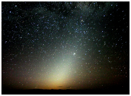
'Hi James ...another picture, this time of the Zodiacal Light as seen from a couple of kilometres from Oamaru at a dark spot .....30 sec exposure f5.6 ISO 800 Canon 300D 16mm wide angle lens' wrote Tony.
Tony Travaglia

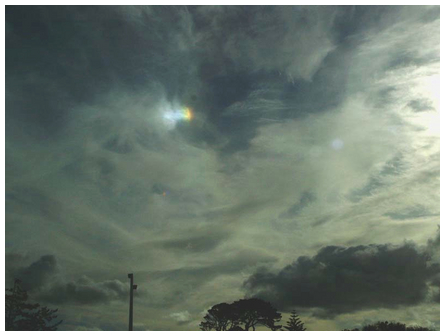
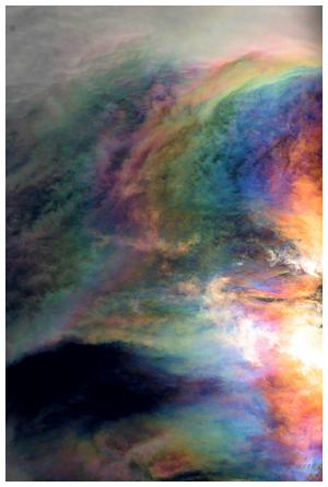
Tony wrote '...Attached find this magnificent cloud irization,.. the best I have ever seen.
Taken from the deck of the house and used a Canon 300D ....zoom lens at 200mm ... 26 August 2006 ...exposure 1200th sec @ f8 ISO 100 ...I was astounded at the range of colours and the vividness of them easily seen as long as the eyes were shaded from the direct sun, by the tree...
weather conditions at the time of shooting 15:15 NZST, temperature out 10.3, humidity 62, dewpoint 3.3, wind chill 10, wind speed 3.3, wind direction 163, barometer 1005 steady,
taken from my wx station....
'
Tony Travaglia

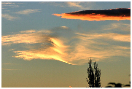
Lenticular clouds over Oamaru.
Darren McManaway

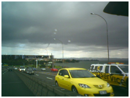
I know this photo isn't the best - sorry about that.
The phone was the nearest photographic device within reach at the time.
And yes ..........don't you just hate those moments when you wish you could just stop the car and get out?!
This image was shot coming over the Auckland Harbour Bridge at around 14:50 on 9 August 2006. The system is around 5-6 km away, over towards Point Chevalier in West Auckland. It developed further than I can show - but my phone crashed so I didn't get any more pics.
Probably not spectacularly enough for claiming a spot on your page, but interesting enough to look at when you look at the clouds surrounding the vortex.
If you study the clouds around the funnel cloud - look either side of it, you can see a cloud formation and the funnel cloud coming down from near the center.
Ross Petherick

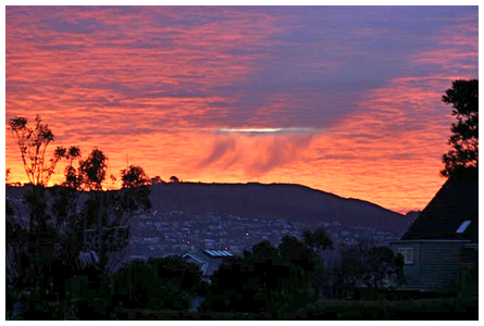
'Taken in Wellington, on the 10 August 2006 from Beacon Hill in Strathmore, looking towards Wrights Hill.
Very strange that there was just one hole in the clouds in what was
otherwise a solid cloud layer. The shadow being cast was from the small
wisps of cloud that were below the "hole". Very strange' wrote Ross.
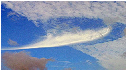
Ian Cooper has also sent some comments about Ross Petherick's photo shown above and Bruce Yorke's photograph shown below. Ian wrote 'Ross Pethrick's shot appears to be a hole punch cloud with the virga having descended through the hole and casting the shadows on the under side of the cloud layer. This is what it appears to be to me, although I have never seen nor heard of such a thing. I am convinced that high altitude virga such as that seen in Bruce Yorke's picture is the classic cause of hole punch clouds. The numerous examples that you have posted in your galleries of hole punch clouds almost all show virga forms above the holes and Bruce's shot is another classic example of this.'
Bruce Yorke

'This cloud formation photo was taken at Maungatapere West of Whangarei several months ago. I have never seen a cloud formation like this before. Could you please tell me more about it' wrote Bruce.
This looks like a classic hole punch cloud Bruce. We showed some similar hole punch clouds on the MetVUW web site
in our Photograph of the Week feature on 19 April 2005 and on 25 October 2005.
Robin Booth

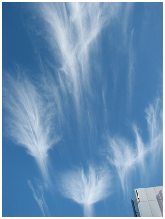
'Even between buildings in Auckland are beautiful clouds' wrote Robin.
David McDermott

David wrote 'Hi James, you may be interested in the following photo taken looking south over Geraldine late afternoon on the 19 September 2006'.
John Herrick

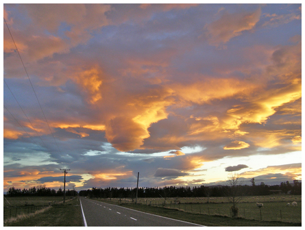
'Photo taken from Wellington Airport, over the Miramar Golf course, towards the hills of Strathmore on September 2006
I use your website for work, (Building) and play (Skiing and fishing).
Keep up the good work' wrote John.
Andrew Blackler

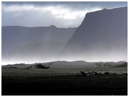
'Hope you like this: half way between Whatipu and Kerekere on Auckland's west coast. Eastern light illuminating the salt spray kicked up by the westerly wind. Taken at about 11:00 on Sunday 28 May 2006' wrote Andrew.
Ben Jackson

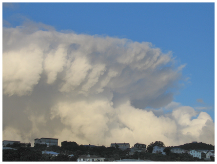
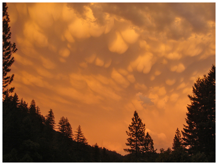
'I took this photo while on holiday in northern California. This show
lasted about an hour and was absolutely amazing. Sadly, I have managed
to corrupt many of the better photos but I think you get the idea.
The website is amazing, we use it a lot in Murchison because it allows
us to watch the rain pretty well so we know when and where we should
be whitewater kayaking' wrote Ben.
Many thanks for your photograph Ben, this is mammatus cloud, the editor's favourite cloud form. See the Previous Photograph of Week section below for other fine photographs of mammatus clouds.
|
SUBMITTING PHOTOGRAPHS
If you would like to submit a weather or weather related photograph to the metvuw.com website please click here and send it/them as an email attachment. Our preference is for unmanipulated full resolution photographs.
Please provide the full name of the photographer and as much detail about the photograph - location, time and prevailing weather. It is also useful to know camera and exposure details and the direction the camera was pointing. Most of the photographs that we publish are from New Zealand, however we are happy to consider interesting photographs of weather phenomena from any part of the world.
We are often approached by book and magazine editors for permission to use photographs shown here. We do not divulge your contact details but are happy to pass on such requests to you as they arise. Copyright of all the photographs shown on the site remain the property of the originator. Submission of photographs implies your permission for us to publish on the metvuw.com site unless you specifically instruct otherwise. Photographs containing logos or other text can not be considered for publication. If you have any further queries please don't hesitate to contact James.
PREVIOUS PHOTOGRAPHS OF THE WEEK
2009
27 November 2009 Noel Becker - South Westland rainbow
20 November 2009 Robin Booth - Pastel skies, Morogoro in Tanzania
13 November 2009 Paddy Darkin - Lightning strike - Whale Island
6 November 2009 Paul Grover - Mt Cook from Hermitage Car Park
30 October 2009 Fritz Schöne - Rainbow south of Wellington
23 October 2009 Linda McGuire - Mt Taranaki and fog from Tikorangi
16 October 2009 Carl Thompson - High level cloud nr Lake Wanaka
9 October 2009 Noel Munford - Sun pillar and upper tangent arc
3 October 2009 John Hunter - Sun pillar, 200miles ne of North Cape
25 September 2009 Joanne Bell - Foggy Waikato River, Huntly
18 September 2009 Murray Cave - Clouds over the Torlesse Range
11 September 2009 Mark Emirali - Rainbow at Whatipu
4 September 2009 Kahl Olsen - Fog, Tukituki Valley from Te Mata Peak
29 August 2009 Mark Merriman - Kelvin Helmholtz instability, U. Moutere
20 August 2009 James Panckhurst - Dew deposition on a trampoline
13 August 2009 Ian Thompson - Frosty morning - Lindis Pass
30 July 2009 Teresa Lamont - Franz Josef Glacier
21 July 2009 Stefan Krivan - Moondog, Palmerston North
13 July 2009 Hamish McCaul - Ice patterns on a car roof
5 July 2009 Trevor Chinn - Rimed spider webs
28 June 2009 Carolyn Blackett - Frosty in the Catlins
21 June 2009 Fiona Bignell - Sunset just out of Methven
14 June 2009 Gavin Dann - Lenticular cloud - Two Thumb Range
7 June 2009 Daniel Dwen - Cloud formation Cape Palliser
31 May 2009 Rachel Christie - Circumhorizontal arc
22 May 2009 Pam Blackwell - Cloud layers over the Volcanic Plateau
15 May 2009 Geoff Cloake - 22° halo
8 May 2009 Colin Langley - Hole punch cloud, Hauraki Gulf
1 May 2009 Steve Robb - Riverton sunset
24 April 2009 David Havell - Moonrise over Ngaruahoe
17 April 2009 Lloyd Esler - Sub Sun pillar, over Southland
10 April 2009 John Krippner - Morning fog, Te Rore, Te Awamutu
3 April 2009 Ulrika Silfverberg - Low cloud, Great Barrier Island
27 March 2009 Lloyd Esler - Fogbow Isla Bank, Southland
20 March 2009 Liz Quilty - Sunset over Auckland
13 March 2009 Scott Wilkinson - Ice buildup on blades of grass, Iceland
6 March 2009 Sheryl Logan - Hole punch cloud, Maungaturoto, Northland
28 February 2009 Alison Graville - Circumhorizontal arc, Auckland
20 February 2009 Robert Fleming - White Island plume and sea fog
8 February 2009 Steve Butler - Victoria bush fire smoke in NZ
1 February 2009 Mark Braithwaite - Electrical storm, Christchurch
25 January 2009 Tim Appelhans - Waterspout, Sumner Bay, Christchurch
16 January 2009 Noel Munford - Morning fog, Okura
9 January 2009 Tristan Hughes - Lenticular clouds, Cook Straight crossing
2 January 2009 Andrew Blackler - 22° halo and circumhorizontal arc, Piha
2008
27 December 2008 Bob Sayer - Towering cumulus, near Townsville
19 December 2008 Carl Thompson - Lenticular clouds, Wanaka
9 December 2008 Bill Claridge - Cloud streets, Banks Peninsula
30 November 2008 David Hood - Mammatus clouds in Dunedin
22 November 2008 Abhishek Singh - Palmerston North sunset
17 November 2008 John Palmer - Cook Strait and Turakirae Head
7 November 2008 Emily Brodnicki - Lenticulars over Mt Nguarahoe
31 October 2008 Geoff Cloake - 22° and 46° halo, parhelia and tangent arc
24 October 2008 Pam Gill - Dawn at Waipukurau
10 October 2008 Noel Munford - Virga, jet contrail, Palmerston North
3 October 2008 Darelle Busfield - Mammatus, Spreydon, Christchurch
26 September 2008 Andrew Hamer - Rainbow over Lyttelton harbour
19 September 2008 Peter Munro - Lenticular cloud over Two Thumb range
12 September 2008 Geoff Tempest - Hoare frost, near Alexandra
5 September 2008 Hugh Thorpe - Filtered sunlight, St Albans, Christchurch
29 August 2008 Robin Booth - Cirrus clouds over Kerikeri
22 August 2008 Anna Humphries - Threatening clouds, Central Otago
15 August 2008 Katja Riedel - Ice crystals, summit of Mt Taranaki
8 August 2008 Matthew McGinnes - Mt Hutt from just outside Methven
1 August 2008 Elizabeth Passuello - Severe easterly gales, Greymouth
25 July 2008 Jerry Zinn - Sunset, Takapuna
18 July 2008 Alex Young - Sunlight, cloud and mountains, Wanaka
11 July 2008 Ian Orchard - Sunlight, cloud and mountains, Wanaka
4 July 2008 Paul Moss - Cloud iridesence, Wellington
27 June 2008 Christopher Picking - Moonrise, Kaituna, Wairarapa
20 June 2008 John Patterson - Wellington fog
13 June 2008 Patrick Davey - Kelvin-Helmholtz wave clouds
6 June 2008 Linda Paterson - New Plymouth sunset
30 May 2008 Craig Ross - Lifting fog in Wairarapa Hills
23 May 2008 Neil Colliver - Mountain shadow, Mount Ruapehu
16 May 2008 Ben Taylor - Fabulous Fiordland weather
9 May 2008 Noel Munford - Rainbow in the Manawatu
2 May 2008 Paul Dulieu - Mammatus cloud, St. Arnaud
25 April 2008 Andrea Buckthought - Funnel cloud, Ngatea
18 April 2008 Rikki Griffin - Westerly showers, Te Anau
11 April 2008 Andrew Rodley - Sunset Panorama Heights Nelson
4 April 2008 Bruce McLennan - Sunset Hamner Springs
28 March 2008 Jan Kaluza - Cloud iridesence over Hamilton
21 March 2008 Shirley Herbert - Misty morning, Kaimanua Ranges
14 March 2008 Kelly Kruger - Altocumulus clouds, at Mangonui
7 March 2008 Shea Evans - Beautiful rainbow, Lake Wakatipu
29 February 2008 Maggie de Grauw - Circumhorizon arc, Tirohia
22 February 2008 Steve Howat - Water spout off Kapiti coast
15 February 2008 Peter Loveridge - Lenticulars from Mt von Bulow
8 February 2008 Marty Rivers - Electrical storm, Perth, Australia
1 February 2008 Steve Thomson - Dove shaped cloud Auckland CBD
25 January 2008 Tony Travaglia - Fisheye photo of halo around sun
18 January 2008 Vicky Orbell - Lightning near Fairlie
11 January 2008 John Wilkinson - Dust devil at Omarama
4 January 2008 Dave Gordon - Across Tasman Bay from Atawhai
2007
28 December 2007 Cameron Hoyle - Funnel cloud near White Island
21 December 2007 Les Edwards - Cloud reflections in Lake Tarawera
14 December 2007 John Coplestone - Cloud caps on Mount Taranaki
7 December 2007 Darren Gedye - Thunderstorm over Tauranga
30 November 2007 Paul van Kampen - Fogbow at the Green Lake
23 November 2007 Olga Zubkova - Sunset at Waikanae
16 November 2007 Tom Hall - Lightning strike, Wellington
9 November 2007 Diarmuid Kingsleigh-Smith - Sunrise in Auckland
2 November 2007 Rona Lomas - Fabulous lenticular over Mt Ngauruhoe
25 October 2007 Cheryl Retallick - Mammatus at Levin
12 October 2007 Liam Anderson - Water spout at Hokitika Beach
5 October 2007 Dale Savage - Mt Ruapehu eruption
28 September 2007 Andrew Blackler - Sun Dog, Onehunga
21 September 2007 Peter Kirby - Lightning strike Gold Coast, Australia
14 September 2007 Rick Brown - Anti-crepuscular rays Anaura Bay
7 September 2007 Don Macalister - Hauraki Gulf weather, Easter 2005
31 August 2007 Sean Clynes - Eclipse of the Moon 28 August 2007
24 August 2007 Andrew Wardell - Spectacular sun pillar Mt Ngauruhoe
17 August 2007 Tony Kellett - Rainbow, Taranaki Street, Wellington
10 August 2007 Philip Blackler - Light scattering off water droplets
31 July 2007 John O'Malley - Rare ice haloes and arcs
4 May 2007 Neil Smart - Glory and the Brocken Spectre
20 April 2007 Andrew Blackler - Waterbow at Titoki, Northland
31 March 2007 Bob Bingham - Flooding at Kerikeri
16 March 2007 John Nysse - Lake Matherson
2 March 2007 Gary Briggs - Lake Pukaki and Aorangi
18 January 2007 Noel Munford - Comet McNaught, viewed from Levin
10 January 2007 Vicky Orbell - Gathering storm, Central Otago
2006
18 December 2006 Helen Greenfield - Port Hills, Christchurch
30 October 2006 Rob Bargh - Taranaki from Ruapehu
16 October 2006 Mike Nicholson - Double rainbow
5 October 2006 Wynston Cooper - Hollyford view
28 September 2006 Quentin Smith - Lightning strike Mount Maud
21 September 2006 Micky Waby - Rainbow over the Rees River
1 August 2006 Micky Waby - Iridescent lenticular cloud formation
10 July 2006 Mel Hodgkinson - Fog in central Wellington
19 April 2006 Phil Bones - Cap cloud on Mt Hooker from Dasler Pinnacles
7 April 2006 Richard Park - Sugar Loaf Islands, New Plymouth
31 March 2006 James McGregor - Total Eclipse of the Sun, Turkey
24 March 2006 Brian Waugh - Wave clouds, Tawa
7 March 2006 Michael MacGregor - Cap cloud on Taranaki
7 February 2006 Dawn McKenzie - Waterspout from Manly, Whangapararoa
24 January 2006 Kelly Cattermole - Lightning at Kirwee
3 January 2006 James McGregor - 22° halo, Southern Wairarapa
2005
13 December 2005 Daniel Lowe - Funnel cloud, Greymouth
29 November 2005 Jim Gabbitas - Sunset in Newmarket, Auckland
1 November 2005 Ron Court - Magnificent wave clouds at Hanmer Springs
25 October 2005 Ron Ovenden - Hole punch clouds at Whatawhata
18 October 2005 John Forsyth - Low level cloud, Whitereia Park
11 October 2005 Adrienne Walczak - Eggs balloon and Balfour Glacier
20 September 2005 Craig Liken - Falling snow, Christchurch
14 September 2005 MetVUW - PM's visit to the home of MetVUW
23 August 2005 Adrienne Walczak - Eggs hot air balloon over Ruapehu
9 August 2005 Helen Bucksey - Rainbow at Tokaanu
2 August 2005 Adrian Godfrey - Lenticular clouds
5 July 2005 Robert Anderson - Ardmore tornado
28 June 2005 Adrian Godfrey - Lenticular cloud off Ruapehu
21 June 2005 James McGregor - Cumulus development over the Tararuas
14 June 2005 Peter Kirby - North Island snow scene + More NZ mammatus
7 June 2005 Bruce Turner - Auckland City fog
31 May 2005 Nanette Sinclair - Foggy cobwebs, Orepuki + US mammatus
24 May 2005 Tony Travaglia - Aurora Australis
17 May 2005 Sue O'Malley - Fog bow, glory and brocken spectre
10 May 2005 Ian Frame - Wellington rainbows
3 May 2005 Ian Orchard - Hagley Park fog
26 April 2005 David Jensen - Atmospheric waves
19 April 2005 Dave Swarbrick - Hole Punch clouds, Auckland
12 April 2005 Michael Franklin - Stewart Island front
5 April 2005 Ian Cooper - Palmerston North funnel cloud
29 March 2005 Jennie McCormick - Spectacular mammatus
22 March 2005 Steve Ancsell - Matamata funnel cloud
15 March 2005 Kelly Cattermole - Kirwee sunset
8 March 2005 Craig Miller - Altocumulus from slopes of Ruapehu
1 March 2005 John Robinson - Gliding above Roxburgh
22 February 2005 Grant Middendorf - CB at Matara
15 February 2005 Pete Bielby - Christchurch sunset
SATELLITE MOVIES
August 2006

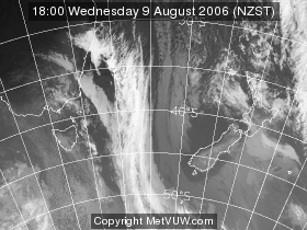
This movie shows the weather for the month of August 2006. Click thumbnail or here to view the 1-31 August 2006 movie. (File size 5.44 Mbs)
PREVIOUS SATELLITE MOVIES
QuickTime movie - 1-31 January 2006. (File size 5.43 Mbs)
QuickTime movie - 1-30 June 2006. (File size 9.24 Mbs)
QuickTime movie - 1-31 July 2006. (File size 5.73 Mbs)
QuickTime movie - severe snow storms 10-13 June 2006. (File size 683.1 kbs)
|


